Perceptions of Public Spaces in Tehran- An Evaluation Platform (HayateTehran)
Project Info
| Year: |
| Client: |
| Location: |
| Status: |
| Program: |
| 2021 |
| Tehran Municipality |
| Tehran, Iran |
| Completed |
| Urban Design Toolkits |
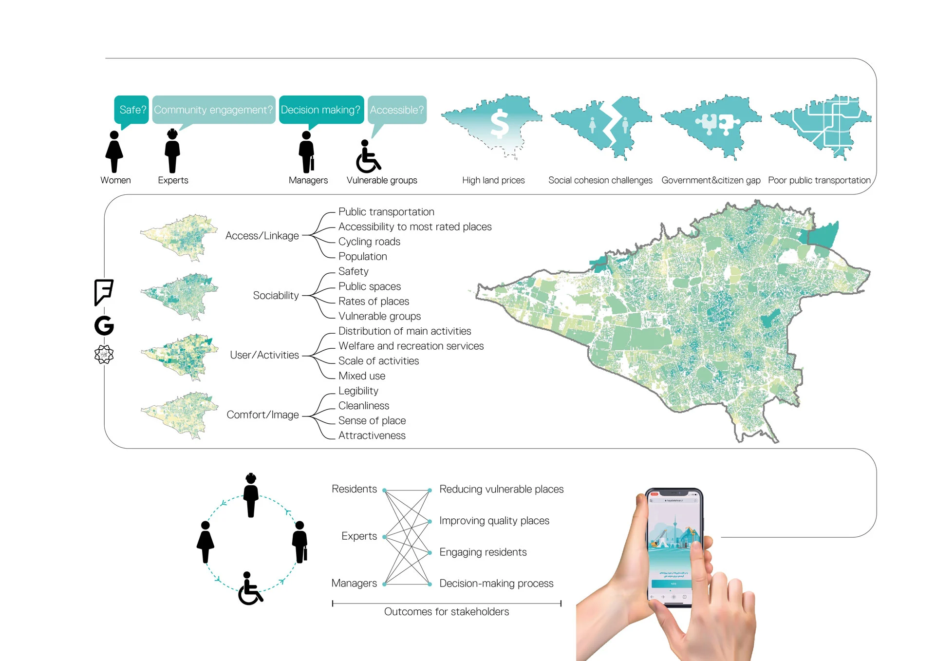
We designed an online platform to share our spatial analysis and evaluation of public spaces of Tehran with people and provide opportunities for their active participation in the city’s future development. To recognize successful public spaces, we collected our basic data from Tehran’s municipality, google places, and foursquare venues information. By using PPS (Project for Public Spaces) criteria for successful public spaces, access and linkages, sociability, uses and activities, comfort and image, we defined 15 indicators to evaluate Tehran’s successful public spaces. For access and linkages, we evaluate accessibility to public transportation, permeability, accessibility to most rated places, cycling roads, proximity to parking lots, and neighborhood population accessibility. To assess sociability, we considered safety, reaching public spaces, and rates of places. The indicators used to evaluate uses and activities were distribution of main activities, welfare and recreation services, and scale of activities; and for comfort and image, we analyzed legibility, cleanliness, and sense of place. We collected our data through Tehran’s municipality basic information, google places and reviews, and foursquare city guide data and analyzed them using network Analysis methods (Reach, Straightness, Gravity, Betweenness). The value of each public space was estimated based on its scores and the resulting map provided in the platform demonstrated neighborhood amenities, scores of four defined PPS criteria and urban municipality project announcement.
The platform was developed to reduce the gap between experts’ opinions and the public. It provides a perfect setting for people to score all indicators for every public space in Tehran, review their neighborhoods, and participate in the ongoing and future development of the city. Citizens can also use the statistical data of this database to look for the information in their living, recreational and working areas. The urban government managers and technical specialists would have the opportunity to hear audience opinions and the platform will help them through the decision-making process.

پروژه شبکه حیات با هدف شناسایی محدودههای دارای پتانسیل در راستای توسعه فضای عمومی تهران بر پایه برهم نهادن لایههای تخصصی و دادههای مردمی از منابع آنلاین نظیر فوراسکوئر و گوگل که با اهداف متفاوتی مبنی بر تجربه زیسته آنان ثبت شده بود، شکل گرفت. سازمان مشاور فنی و مهندسی شهر تهران در راستای ارتقا كمی و كيفی فضاهای عمومی شهری با همراهی تیم نشا پس از انجام مطالعات فنی و تخصصی، بر پایهی ۲۲ شاخص و چهار گروه معیاری، محدودههای مستعد شکلگیری فضاهای عمومی را در محلات تهران شناسایی کردند اما از آنجایی که بخشی از شاخصهای شکلگیری خاص این فضاها مبتنی بر نظرات صریحتر مردمی بود، پلتفرم آنلاین شبکه حیات با کمک لابراتوار نوآوری شهر آینده در راستای کاهش فاصلهی آرای متخصصین و مردم توسعه یافت. پلتفرم حاضر بر مبنای چهار مؤلفه اصلی امنیت، پاکیزگی و آراستگی محیط، دسترسی به مکانهای فراغتی و حملونقل عمومی به عوان شاخصهایی پراهمیت از دیدگاه مردم در شکلگیری فضاهای عمومی، طراحی و پیاده سازی شد. شهروندان تهران میتوانند نظرات و تجربیات خود را در قالب بازخورد دربارهی محلههای مختلف تهران ثبت کنند و با استفاده از دادههای آماری و نظرات سایر کاربران، محلههای شهر را به منظور زندگی، تفریح یا کار ارزیابی و بررسی کنند. همچنین در این پلتفرم تلاش شده است تا پروژههای توسعهی فضاهای عمومی تهران توسط شهروندان ارزیابی شده و اصلاح گردد و پروژههای آتی متناسب با تجربیات زیستی مردم و نظرات آنها شکل بگیرد و با عنایت به گسترش فضای عمومی در ساحت مجازی، این پلتفرم در آینده میتواند نقش مهمی در اتصال اجتماع فضای مجازی به فضای عمومی نمود یافته در شهر داشته باشد.