Landscape Design of Mahallat Old Bazaar

Landscape Design of Mahallat Old Bazaar

Project Info
Year:2012
Type:Commission
Program:Public Space
Client:Mahalat Municipality
Location:Mahalat, Iran
Status:Constructed
Awards:Winner of Memar Award, 1391
Partner in Charge:Shadi Azizi
Project Management: Hamidreza Mousavi
Technical Management:Mojtaba Safdarnejad
Design Team: Shahab Mirzaeian, Farshad Kazerouni
Technical Design: Kaveh Khajouie
Technical Adviser: Amirmahdi Mastouri, Abbas Fotouhi
Electrical Engineering:Mohammad Bozorgnia
Mechanical Engineering:Amir Hasanzadeh Langeroudi
Construction Supervision:Nabizadeh
Presentation:Mahan Mehrvarz
Photography:Mahan Mehrvarz

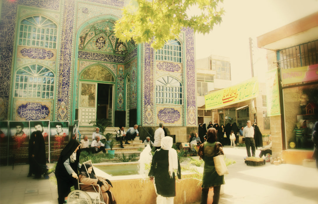
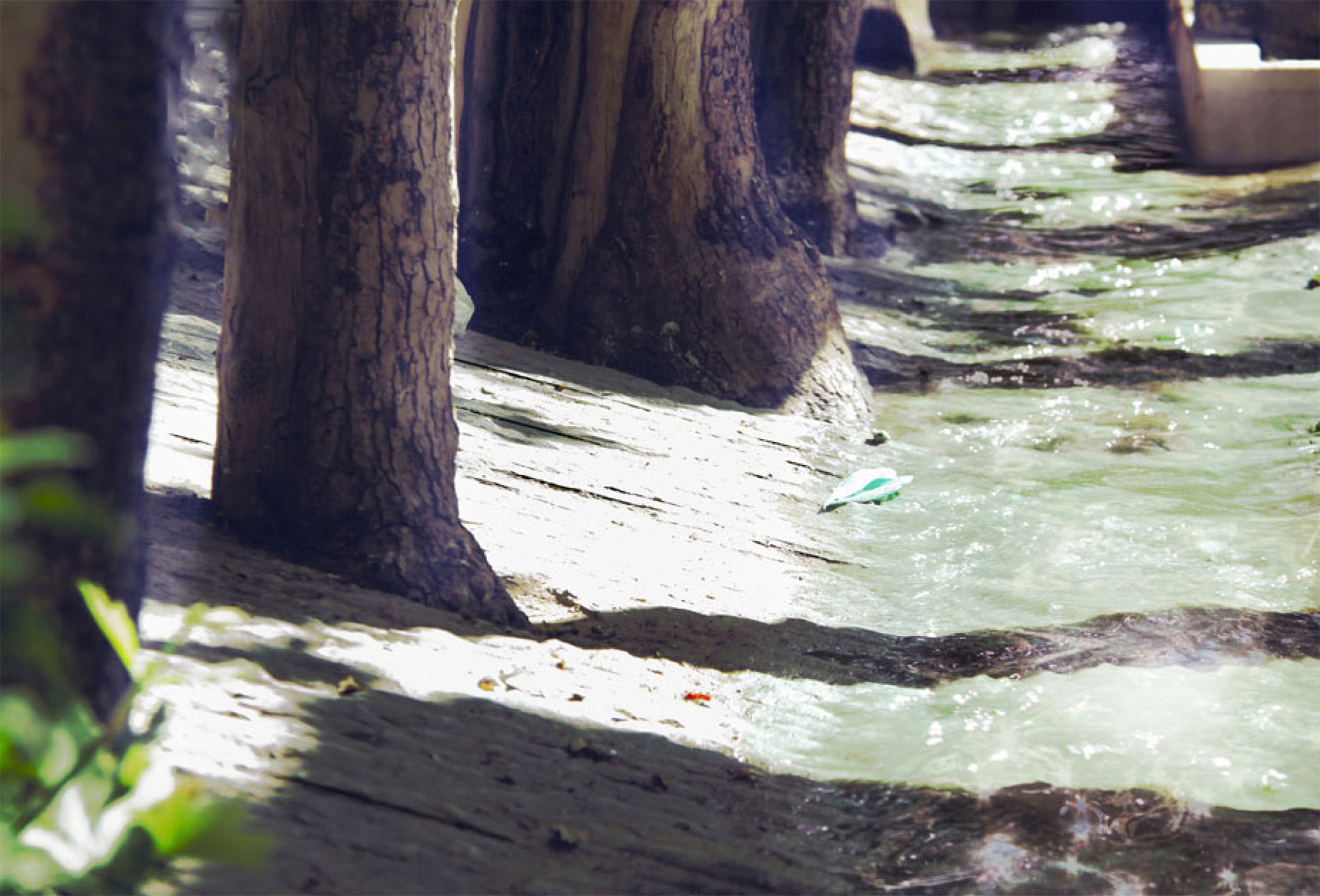
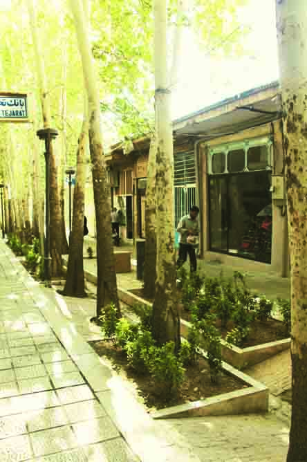
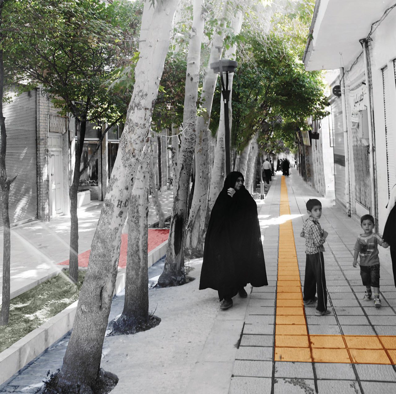
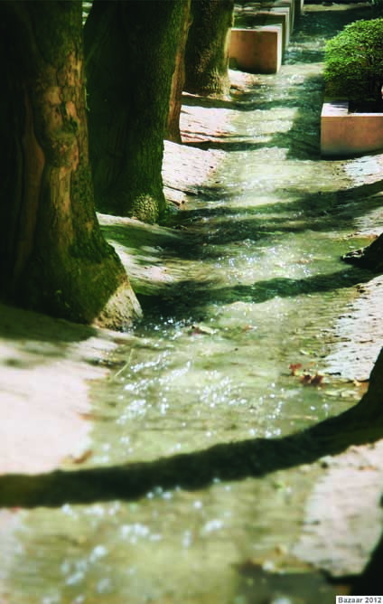
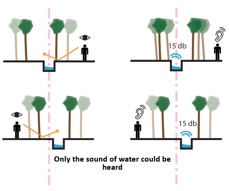
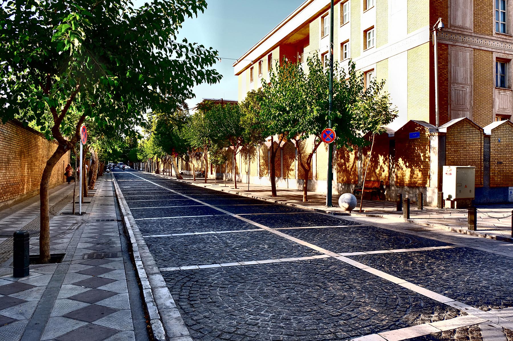
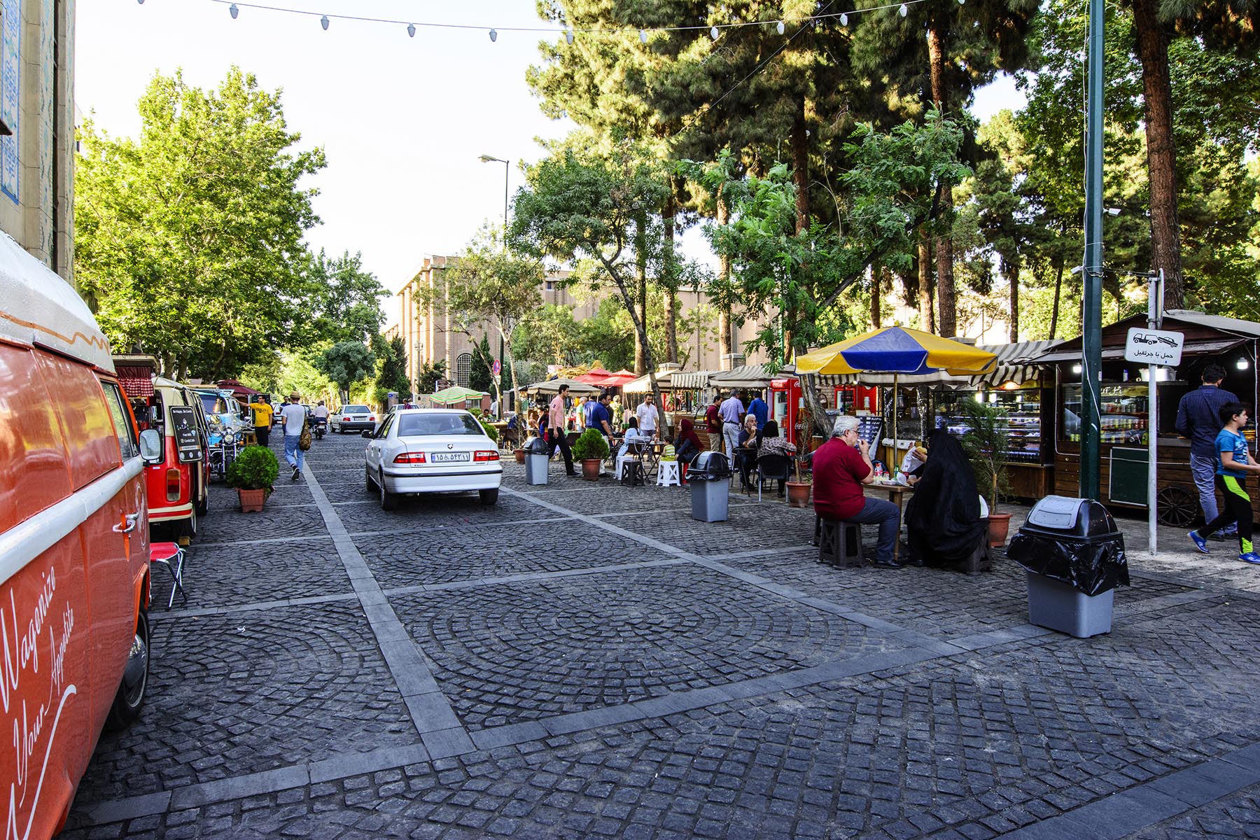
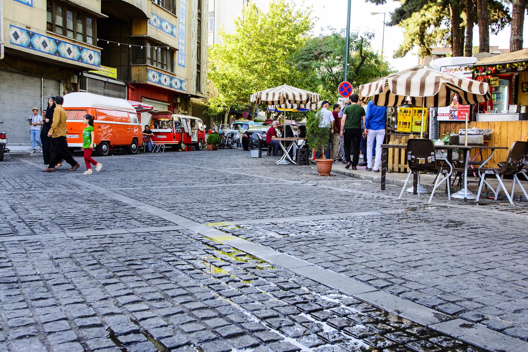
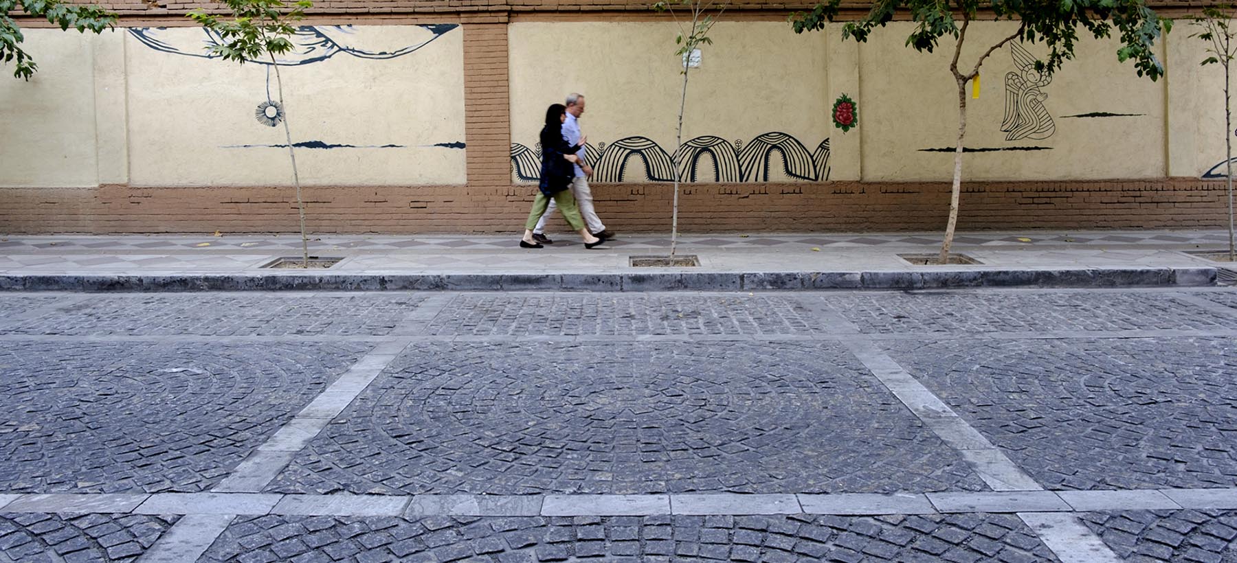
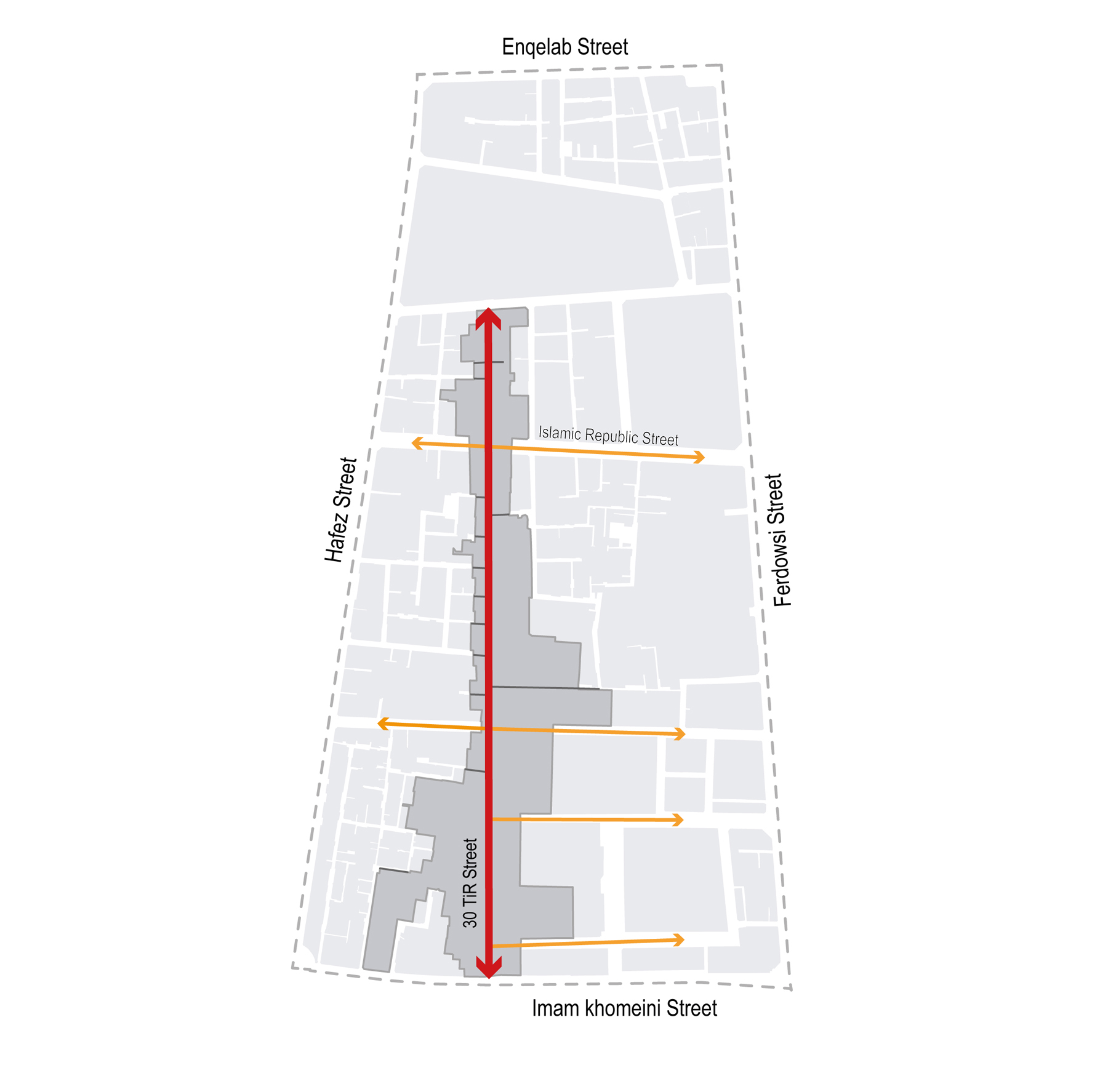
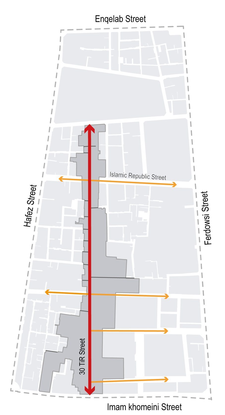
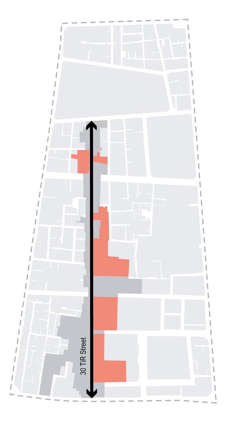
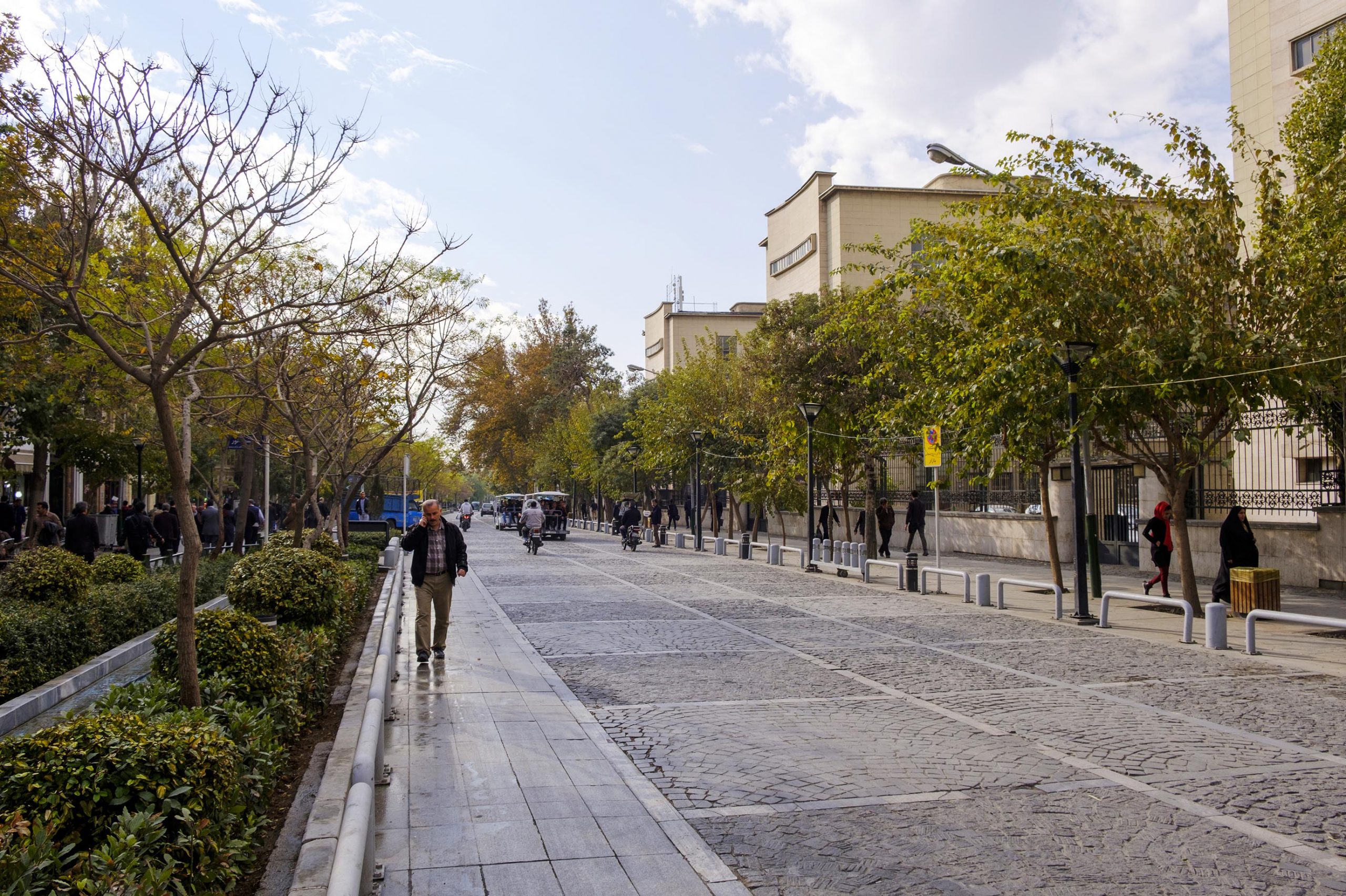
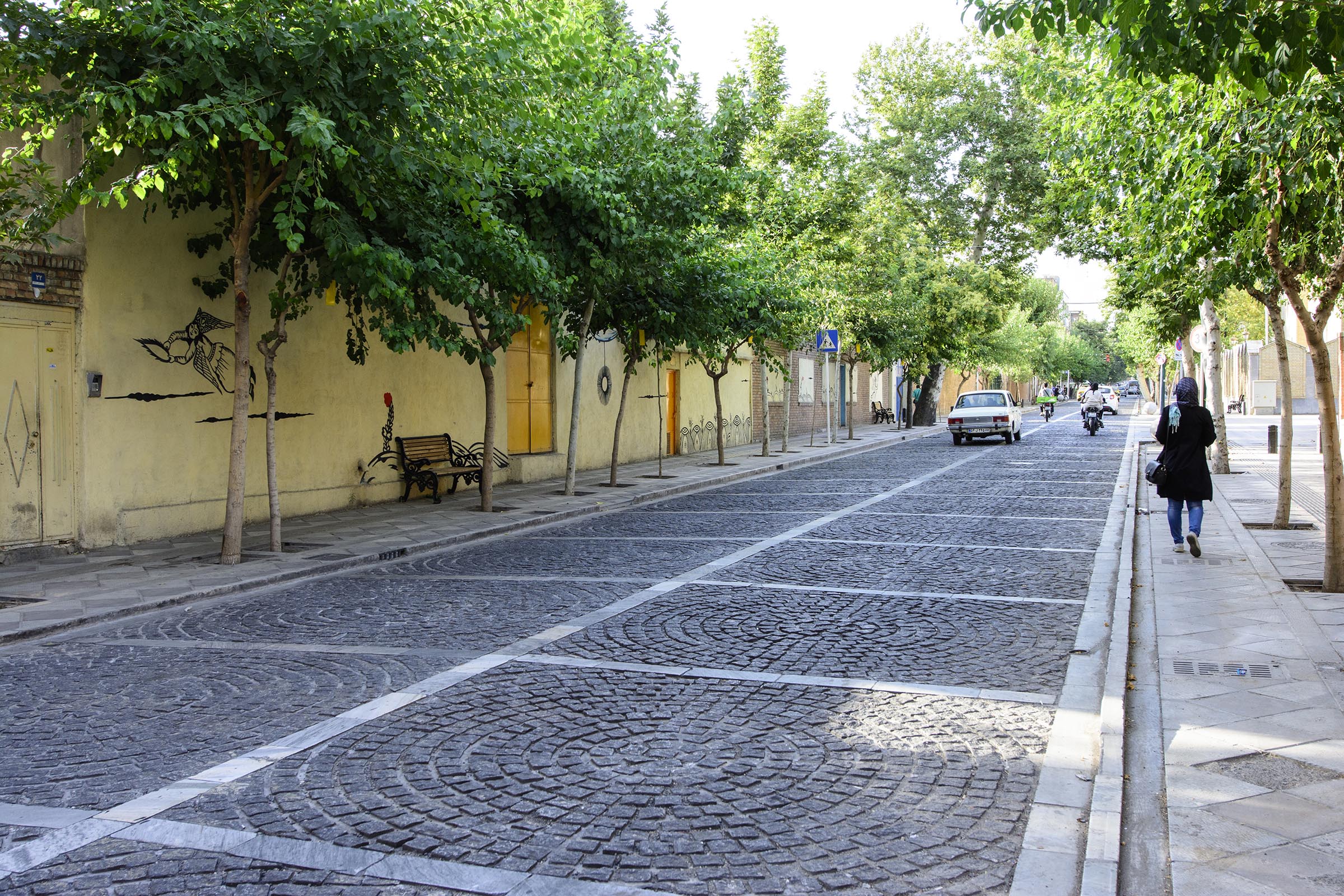
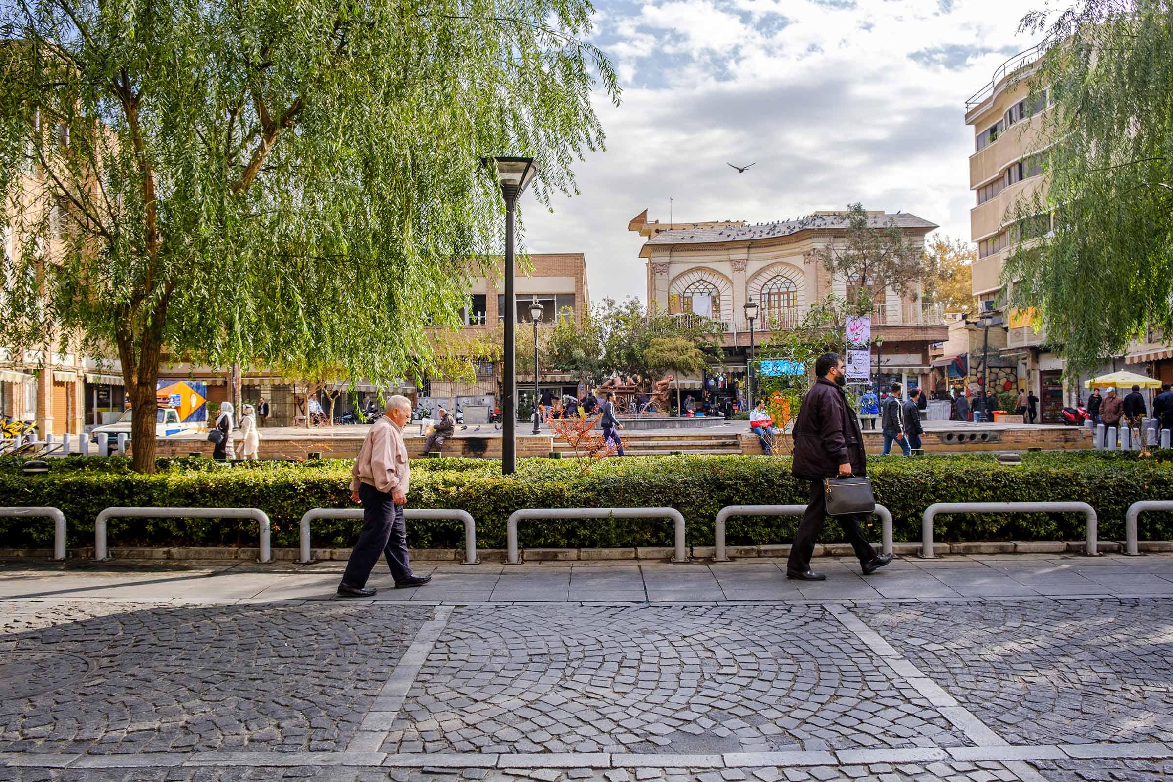
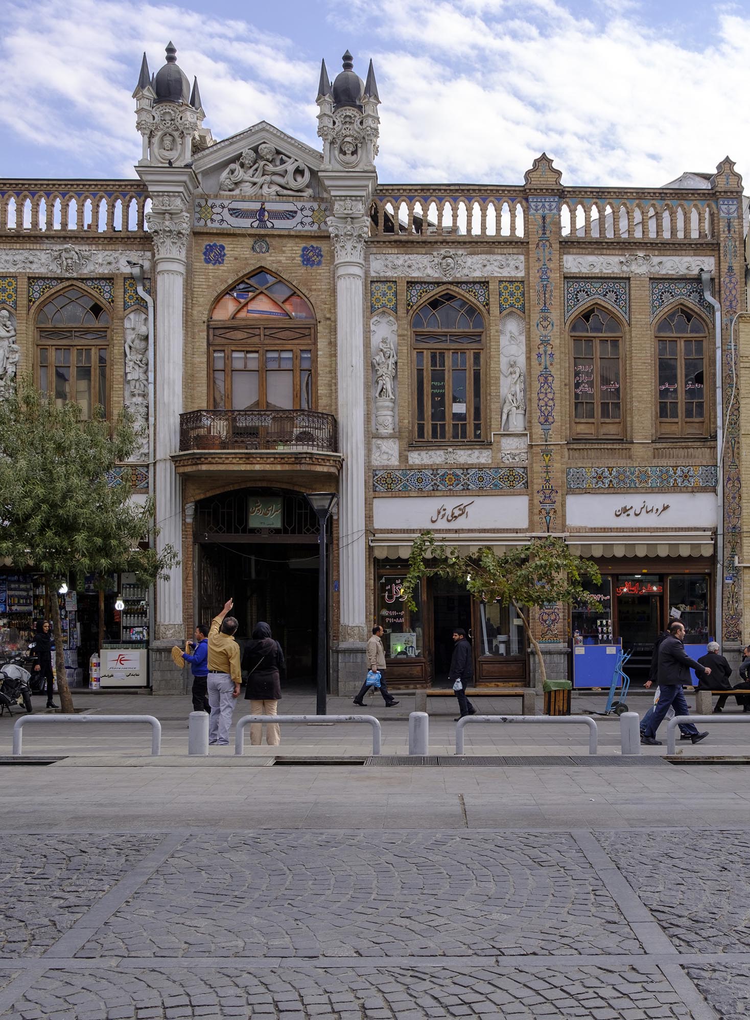
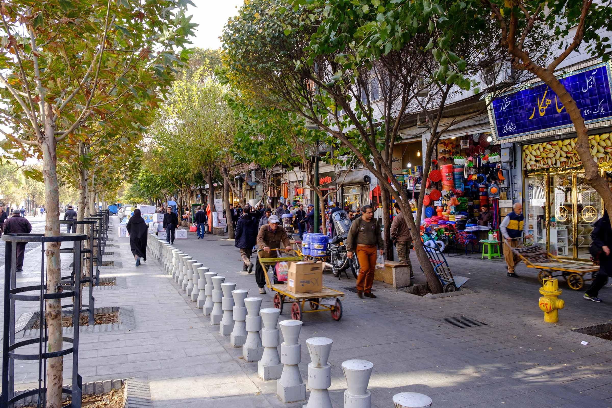
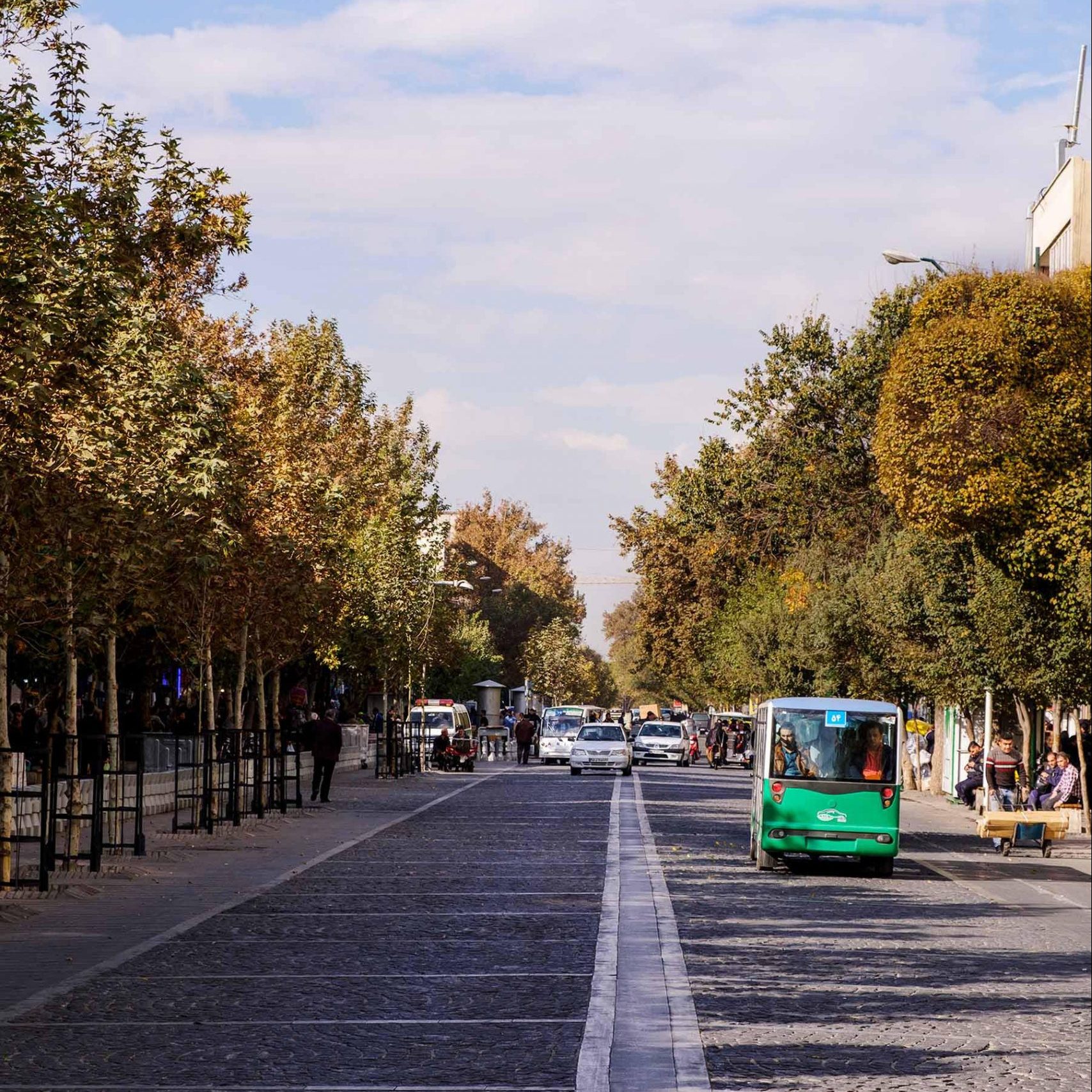
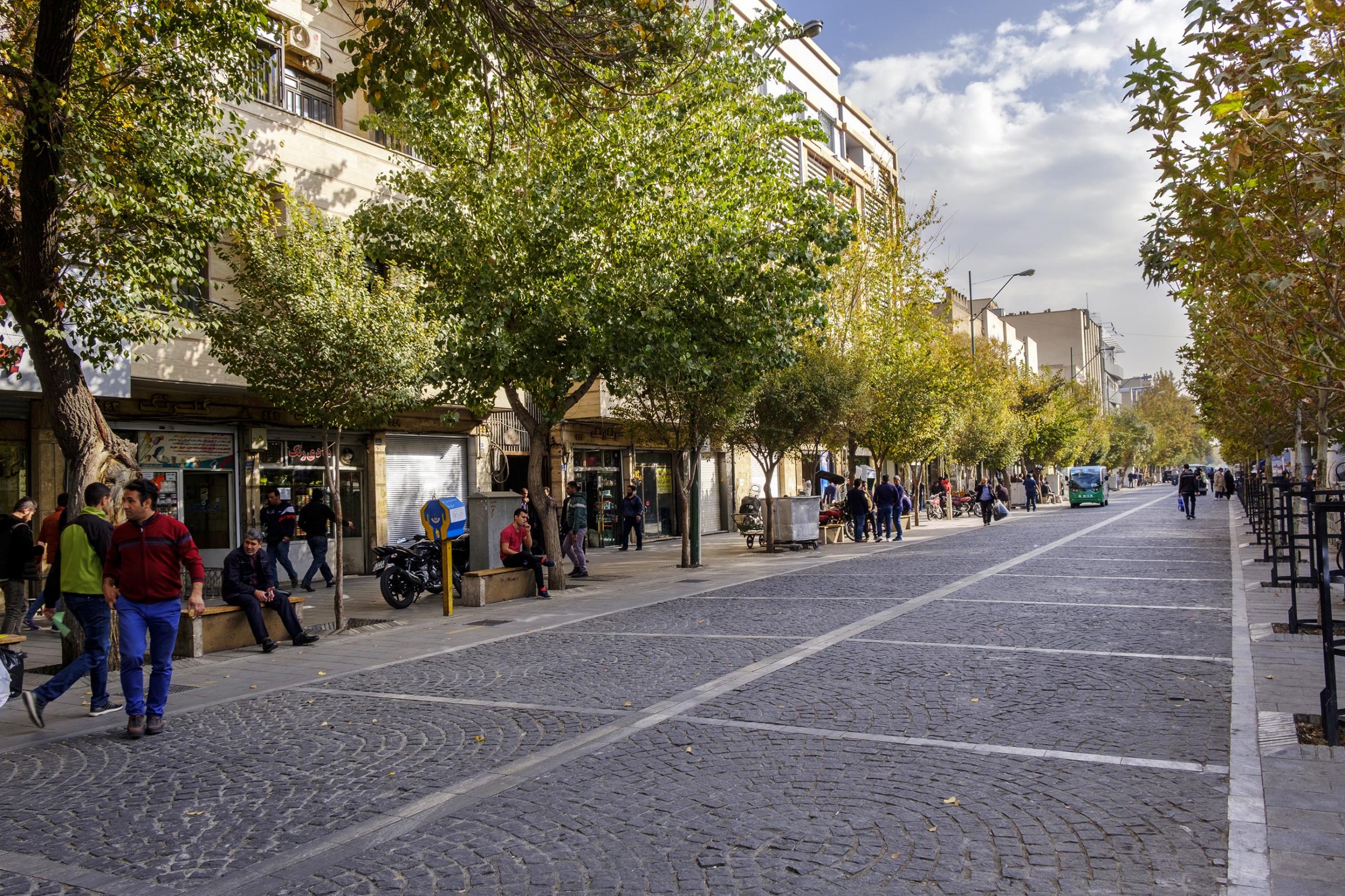
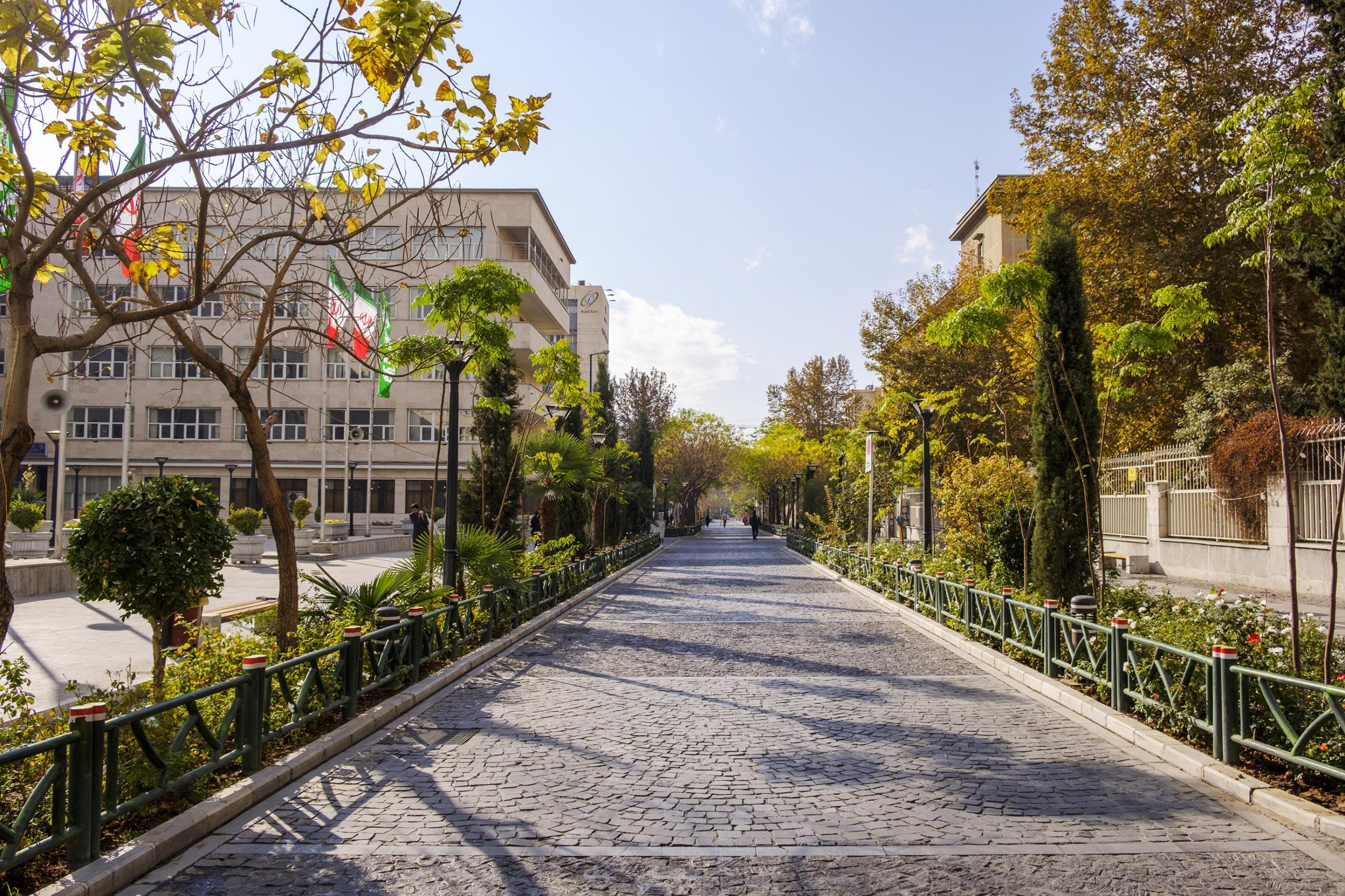
Mahallat bazaar is located in the historic north of the city and near the gardens and natural resorts of Sarcheshme. This bazaar is the backbone of the texture and a link between important elements like hussainiya and mosque. From one side it is adjacent to the access point of the natural attractions of Sarcheshme for the tourists and the natives, and from the other side it reaches the historic Goushe cemetery. Mahallat bazaar is not roofed and has the sky as its only limit, which along with the presence of the foliage of the trees and the water has turned this bazaar into a unique place which is one of the liveliest and most thriving parts of the city and a platform for the social interactions of the people.In order to promote the role of bazaar as a secure and attractive axis for the pedestrians, it was necessary to relocate the pack station of the products to the back of the bazaar. With the consent of the shop-owners, the traditional method of moving the products with wheelbarrows was restored and the use of vehicles, except for emergency (ambulances and fire-fighting vehicles), was limited. Two secondary bazaars of Kohne and Vahid branch from the main bazaar. After the design of the main bazaar in the first phase, the design and organization of Vahid bazaar and the design of the pavements and the front of the Kohne bazaar and turning it into a market for hand-made and local items were designated for the second phase.The necessity for public participation in the process of planning, design, and implementation of the project and the management of the shop-owners in using and conserving the project required interactions with the sellers which its most important result was restoring an old qanat and distributing its water in the bazaar. The main idea of the plan was changing the bazaar from a pedestrian axis dominated by loading vehicles to a secure pedestrian path and a place for rest, leisure, and social, religious, or ritual gatherings – especially in front of the mosque of the bazaar. This goal was achieved by removing the hindrances and inappropriate installations, bringing the pedestrian path on both sides of the water to a same level, building many transverse access points in the bazaar,  correcting the pattern of the movement of the water in bazaar, creating different visual qualities in the path of the water by combining it with plants, and finding resting places among the trees.


In order to improve the irrigation of the trees, the slope was added to the existing horizontal gardens and water paths were found for other plain gardens. Also, a diverse category of flowers – especially flowers that can grow in Mahallat – was used to create colorful areas in the bazaar. Short and medium lighting elements have replaced the previous long lamp posts which the trees blocked their lights. This resulted in the increase of the working hours of the bazaar, with the least possible amount of spending. The travertine cover of the pavements was reused with a new design and geometry in the paving. The white background of the pavements bolds the shadow of the trees and emphasizes the presence of nature. For peddlers and unofficial sellers which are one of the main sources of the boom of the bazaar, a place near Vahid bazaar in the next developments has been considered.

بازار محلات در هسته تاریخی شمال شهر و در نزدیکی باغ‌ها و تفرجگاه طبیعی سرچشمه قراردارد. این بازار که ستون فقرات بافت و عامل پیوند‌دهنده عناصر شاخصی همچون حسینیه و مسجد است، از یک سو متصل به محور دسترسی گردشگران و مردم بومی به جاذبه‌های طبیعی سرچشمه و از سوی دیگر امتداد آن به آرامستان تاریخی گوشه می رسد. بازار محلات سرپوشیده نیست و سقفی از آسمان و شاخ و برگ درختان وجود آب، آن را به مکانی متمایز تبدیل کرده که یکی از سرزنده‌ترین و پررونق‌ترین بخش‌های شهر و مکان تعاملات اجتماعی مردم است.

لازمه ارتقای نقش بازار به عنوان محوری پیاده، جذاب و امن، انتقال محل‌های بارگیری و باراندازی به جداره پشت بازار بود. با هماهنگی کسبه روش سنتی حمل بار با چرخ دستی احیا و ورود وسیله نقلیه جز در موارد اضطراری(آمبولانس و آتش نشانی) محدود شد. دو محور فرعی بازار کهنه و بازار وحید از مسیر اصلی بازار منشعب می‌شود که علاوه بر طراحی راسته اصلی در مرحله نخست، ساماندهی و طراحی راسته بازار وحید و طراحی کف و جداره راسته بازار کهنه و تبدیل آن به محل عرضه صنایع دستی و بومی شهر در مراحل بعد دستور کار قرار‌گرفت.

ضرورت مشارکت مردمی در مراحل برنامه‌ریزی، طراحی و ساخت پروژه و نیز مدیریت کسبه در بهره‌برداری و نگهداری از پروژه، تعامل با بازاریان را ایجاب می‌کرد که مهم‌ترین دستاورد آن کمک به احیای یک قنات قدیمی و جاری نمودن آب آن در بازار بود. تبدیل بازار از یک مسیر پیاده تحت سیطره وسایل نقلیه بارگیری و باراندازی به مسیر پیاده‌ای امن و محل استراحت، فراغت و گردهم‌آیی‌های اجتماعی آیینی و مذهبی – به ویژه در جلوخان مسجد بازار- ایده پایه‌ای طرح است که از طریق حذف موانع و الحاقات نامناسب و هم‌سطح کردن مسیر پیاده دو سوی محور آب، برقراری دسترسی‌های عرضی متعدد در طول بازار و اصلاح الگوی حرکت آب در میان بازار و ایجاد کیفیت‌های متفاوت بصری در مسیر آب در ترکیب با گیاهان و مکان‌یابی محل‌های مکث و استراحت در لابه‌لای درختان مسیر شد. برای بهبود آبیاری درختان، مقطع باغچه‌های افقی موجود به سطوح شیبدار تغییر شکل پیدا کرد و مسیرهای آب برای سایر باغچه‌های همسطح فراهم شد. از تنوع گونه‌های گیاهی نیز به ویژه گل‌های قابل پرورش و نگهداری در شهر محلات برای ایجاد فضاهای رنگی در بازار استفاده شد. عناصر نورپردازی کوتاه و متوسط جایگزین پایه چراغ‌های بلند قبلی شد که انبوه درختان بازار مانع انتشار روشنایی‌شان می شد. این کار به افزایش زمان مفید مراجعه به بازار با حداقل هزینه ممکن، پوشش تراورتن موجود در کف بازار برچیده شد و با طرح و هندسه‌ای متفاوت دوباره در کفسازی مورد استفاده قرار‌گرفت.زمینه سفید کفسازی سایه درختان را با شدت بیشتری بر زمین نمایان و حضور طبیعت را در بازار تاکید می‌کند. برای دست فروشان و کسبه غیررسمی که یکی از عوامل اصلی رونق بازار هستند، محلی کنار بازار وحید در توسعه آتی در نظر گرفته‌شد.

Landscape Design for Si-E-Tir Street

Landscape Design for Si-E-Tir Street

Project Info
Year:
Type:
Program:
Client:
Size:
Location:
Status:
2016
Commission
Public Space
Tehran Municipality, Region 12
1.2 hectares
Tehran, Iran
Constructed
Partner in Charge:Hamidreza Mousavi
Project Management:Shadi Azizi
Lead Designer:Ali Naghavi Namini
Architectural Design Coordination:Amir Lakpour
Urban Design Coordination:Arezoo Khamesi
Design Team:Shirin Moshiri, Atiyeh Akrami, Niloufar Ahmari, Shiva Ashrafi
Study Team:Farnaz Farshad, Marjan Shojaie, Shadnaz Azizi
Technical Design:Amir Lakpour
Civil Engineering:Hani Yazdi
Mechanical Engineering:Alireza Ghazizadeh
Electrical Engineering:Reza Habib
Project Control: Mahsa Mirsamadi
Construction Supervision:Amir Lakpour
Creative Direction:Mohammadmahdi Zanjanian
Presentation:Niloufar Soudmand, Nahal Kashani, Masoumeh Hosseinzadeh
Photography:Meysam Jalili

30 Tir Street, located in Tehran, is one of the few axes that due to its location in the historical zone of the city and the existence of important tourism and recreational activities, the daily time period of its activities is varied, and as a result, is very lively. Through the deployment of the strategic plan for turning the historical streets of ​​Tehran into pedestrian paths, the manner of using this street has been gradually changed from a street with only a through-traffic function to a recreational street.

The project of designing Landscape and urban facade design for 30 Tir Street in 2016 was prepared by the commission of the Municipality of District 12, in an area of ​​12,000 square meters. The most important goal of this plan is to anticipate the requirements that will facilitate the process of public attendance. This project has been designed in two parts: design of the ground and the facade and in three spatial sequences (according to the characteristics of the street). The range of the first space sequence includes historical buildings with a grange pattern. The second and third sequences include buildings that have a mixed pattern and are often built in the second Pahlavi period, as well as buildings with a shell facade that are more recently constructed.

In designing 30 Tir Street, by considering different types of enclosures and mixing activities in each of the spatial sequences and using the details of the facade, materials, colors, and compositions of the street environment, different approaches in urban facade design and formulation of ground rules are provided.

خیابان سی تیر واقع در شهر تهران، از معدود محورهایی است که به‌واسطه استقرار در محدوده بافت تاریخی شهر و به سبب وجود فعالیت‌های مهم گردشگری و تفرجی، بازه زمانی فعالیت‌ها در آن متنوع بوده و درنتیجه از سرزندگی بالایی برخوردار است. در طرح راهبردی پیاده‌راه سازی حوزه تاریخی شهر تهران، نحوه استفاده از این خیابان به تدریج دگرگون شده و از خیابانی با عملکرد عبوری صرف، به خیابانی عبوری-تفرجی تغییر ماهیت داده‌است.

پروژه طراحی سیمای زمین و تدوین ضوابط جداره خیابان سی تیر در سال 1395به سفارش شهرداری منطقه 12 تهران، در محدوده‌ای به مساحت 12000 متر مربع تهیه شد. مهم‌ترین هدف این طرح پیش‌بینی الزاماتی است که فرآیند حضور مردم را تسهیل کند. این پروژه در دو بخش سیمای زمین و سیمای جداره و در سه سکانس فضایی (با توجه به ویژگی‌های خیابان) طراحی شده‌است. محدوده سکانس اول فضایـی در برگیرنده ابنیه تاریخی با الگوی کوشکی است. سکانس‌های دوم و سوم، هم شـامل ساختمان‌هایی می‌شوند که الگوی ترکیبی دارند و اغلب در دوره پهلوی دوم ساخته شده‌اند و هم شامل ساختمان‌هایی با نمای پوسته‌ای و متعلق به ساخت‌و‌سازهای دوره اخیر هستند. در طراحی خیابان سی تیر، با در نظر گرفتن انوع مختلفی از میزان محصوریت و اختلاط فعالیت‌ها در هر یک از سکانس‌های فضایی، و بهره‌گیری از جزئیات نما، مصالح، رنگ و ترکیبات بدنه شهری با محیط خیابان، رویکردهای مختلفی در طراحی جداره و تدوین ضوابط ارائه شده‌اند.

Historic Buildings

Feasibility Study for Walkable Spaces of the Historic District Tehran

Feasibility Study for Walkable Spaces of the Historic District of Tehran

Project Info
Year:2010
Type:Commission
Program:Strategic Plan
Client:Tehran Municipality
Size:697 hectares
Location:Tehran, Iran
Status:Completed
Project Management:Shadi Azizi
Project Coordination:Marjan Shojaie
Urban Studies:Mojtaba Safdarnejad, Shadnaz Azizi, Mahdi PourPeykari, Mozhdeh Mahdavi Moghadam, Somayeh Esmaili, Tiam Sharifi
Social Studies:Mohammad Ameli, Marjan Shojaie
Presentation:Masoumeh Hosseinzadeh
Photography:Meysam Jalili

In recent decades, controlling the movement of vehicles in the city and the construction of axes and special pedestrian paths have attracted much attention as ways to encourage the presence of people in urban spaces.

The importance of such solutions has caused the plan to create walkways in the historical zone, as one of the priority plans in the comprehensive plan for the city Tehran.

In 2011, the plan to create walkways in the historical zone of ​​Tehran, in order to reduce the traffic and to create walking paths, bicycle lanes, and public transport inside the Safavid old wall, in an area of ​​697 hectares was commissioned by Tehran Municipality.

This plan has been implemented in two strategic and immediate fields:

The strategic area (Old Naseri walls of Tehran) in terms of urban divisions, corresponds to the 12th district and parts of the 11th district of Tehran and is located in the area bounded to ​​Enghelab streets from the north, Kargar from the west, 17 Shahrivar from the east and Shush from the south. The immediate field is limited to Jomhouri Street from the north, Rey Street from the east, Molavi Street from the south, and Vahdat-e-Islami Street from the west.

From the results of this strategic plan in the area of ​​Naseri and Safavi walls, we can mention the dominance of the pedestrian to car axes and equipping the walkways with urban furniture in accordance with the needs of all citizens.

ایجاد پیاده‌راه حوزه تاریخی شهر تهران

در دهه‌های گذشته، كنترل حرکت وسايل نقليه موتوری در بافت شهر و احداث محورها و مسیرهای مخصوص پیاده به عنوان راهکارهایی برای تشویق حضور مردم در فضاهای شهری، توجه زیادی به خود جلب کرده‌اند. اهمیت این راهکارها باعث شده تا طرح ایجاد پیاده‌راه محدوده حوزه تاریخـی، به‌عنوان یکی از طرح‌های موضعی دارای الویت در سند طرح جامع شهر تهران در نظر گرفته شود.

در سال 1390 ، طرح ایجاد پیاده راه محدوده حوزه تاریخی شهر تهران، با هدف کاهش بار ترافیک سواره شخصی و ایجاد محورهای پیاده، دوچرخه وحمل و نقل عمومی در محدوده حصار صفوی، در محدوده‌ای بـه وسعت 697 هکتار و به سفارش شهرداری تهران تدوین شد. این طرح در دو حوزه راهبردی و بلافصل انجام شده است:

حوزه راهبردی (حصار ناصری تهران قدیم) از نظر تقسیمات شهری، بر منطقه 12 و بخشی از منطقه 11شهر تهران منطبق است و در محدوده خيابان های انقلاب از شمال، کارگر از غرب، 17 شهریور از شرق و شوش از جنوب قرار دارد.

حوزه بلافصل از شمال به خيابان جمهوری، از شرق به خیابان ری، ازجنوب به خيابان مولوی و از غرب به خيابان وحدت اسلامی محدود می‌شود. از نتایج این طرح راهبردی در محدوده حصار ناصری و صفوی می‌توان به غلبه محور پیاده به سواره، و تجهیز پیاده‌روها به مبلمان‌های شهری متناسب با نیاز همه شهروندان اشاره کرد.

Darband&Darabad Restoration Strategic Plan

Darband&Darabad Restoration Strategic Plan

Project Info

Year:       2017

Client:     Tehran Municipality

Size:        2300 Hectares

Status:    Constructed

Location: Darband,Tehran,Iran

Team

Project Management:  Hamidreza Mousavi

Executive Management:  Mojtaba SafdarNejad

Environmental Studies:  Shadnaz Azizi

Urban Studies:  Farnaz Farshad, Mohammadmahdi Zanjanian, Arezoo Khamesi, Yalda Seirafi

Social Studies:  Marjan Shojaei

River Engineering Studies:  Hashemi

GIS: Marjan Shojaei, Negar Ahmari, Yalda Seirafi

Creative Direction: Mohammadmahdi Zanjanian

Graphic Design: Masoumeh Hosseinzadeh

Photography: Meysam Jalili

Rivers of Tehran, especially Darband and DarAbad have a double-edged essence. From one perspective, they hardly have a place in people’s image of the city , probably because of the simple fact that historically, the city’s water supply was based on a network of qanats. Hence, long before turning into canals, these rives were  considerable barriers for development instead of a vital source of life. From another perspective, they are a significant asset in regards to current environmental risks resulting from climate change.

In spite of the importance of these natural resources, inharmonious development of the cities, not basically embracing the natural environment potentials has disrupted the supposed built-natural balance. Gradual receding of urban rivers surrendering the natural setting to artificial concrete structures is an eyesore yet familiar example. Past decades uncoordinated conducts and the destructive effects of  simply eliminating rivers  from development process have  deprived both citizens and city management from its beneficiary so long. The trend led to even more reductive approach changing the canals to an unauthorized sewage network.  Whereas urban rivers are believed of the ability to play an influential role in rekindling the balance between built urban spaces and nature.

Tehran’s Rivers and Qanats Restoration is a project risen from problems stated above and aims to change current approaches with a hope to revive natural organs of Tehran. This plan was delegated to joint ventures including a River Engineering and an Urban studies consultant in form of three coordinated projects for the seven rivers of Tehran and was financed by the Engineering and Development Organization of the City of Tehran (EDOCT).

علي­رغم اهميت اين منبع طبيعی، گسترش ناموزون شهرها بدون بهره­گيری از توان­‌های محيطی طبيعی، تعادل ميان طبيعت و شهر را مختل نموده که از آن جمله مي­توان به حذف تدريجی رودخانه­‌های شهری از بستر شهر و ايجاد سازه­‌های بتنی مصنوع به عنوان جايگزين عناصر طبيعی رودخانه اشاره نمود. به عبارتی اقدامات و دستکاري­‌های ناهماهنگ انجام شده در طول ساليان متمادی و دهه­‌های گذشته و اثرات مخرب رويکرد حذف و محدودسازی رودخانه­‌ها و مجاری آبی، از ديرباز باعث بروز مشکلات جدی برای شهروندان و مديريت شهری شده است. اين روند تا جايی ادامه يافته که از  مجاری آبی برای تخليه و هدايت فاضلاب شهری استفاده مي­گردد. حال آن‌که رودخانه‌­های شهری می‌توانند نقش موثری در جهت تعادل بخشی ميان فضای انسان ساخت شهر و طبيعت و همچنین ارتباط انسان با طبيعت ايفا نمايند.

طرح احیا و ساماندهی رودخانه‌ها و قنوات شهر تهران پروژه‌ای است که از بطن همین مسائل و مشکلات و با هدف تغییر رویکرد حاکم و احیاء اندام‌های طبیعی شهر تهران تعریف شد. این طرح در قالب سه پروژه هماهنگ برای رودخانه‌های هفت‌گانة تهران در سازمان مشاور فنی و مهندسی شهر تهران تأمین بودجه و برای انجام مطالعات و تدوین طرح به گروه‌های مشارکت شامل یک مشاور رودخانه و یک مشاور معمار- شهرساز سپرده شد.

Site Appraisal

Strategies Table

Tehran Region 3 Watercourses Restoration Strategic Plan

Tehran Region 3 Watercourses Restoration Strategic Plan

Project Info

Year:       2018

Client:     Tehran Municipality

Size:       400 Hectares

Status:    Constructed


Location: Tehran,Iran

Team

Partner in charge:  Hamidreza Mousavi

Project Management:  Shadi Azizi

Design Manager:  Ali Naghavi Namini

Project Coordination:  Marjan Shojaei

Urban Studies: Shadnaz Azizi, Mahdi Poirpeykari, Mojtaba Safdarnejad, Mojdeh Mahdavi, Ahmad Khoshdel

Social Studies: Mohammad Ameli

Design Team: Tiam Sharifi, Mozhdeh Mahdavi, Yalda Seirafi, Nastaran Esmaeil Beygi, Farshad Kazerooni, Mohammadtaghi Dibaei, Mahdi Pourpeykari, Somayeh Esmaeili

Creative Direction: Mohammadmehdi Zanjanian

Graphic Design: Masoumeh Hosseinzadeh

With the constant development of Tehran during the recent years, intermittent streams that had formed the structure of the city – and were once a blessing for urban life – are now considered as an environmental threat. Flooding issues caused by the immethodical constructions and poor management of the urban spaces has forced the municipal authorities to confine Tehran’s intermittent streams into concrete walls. These decisions for the management of the urban water basins gradually restructured Tehran. In this new spatial structure, perennial and intermittent streams were covered and constrained in concrete walls and so disappeared from the life of the citizens. The intermittent streams restoration plan was conducted by the Municipal region 3 of Tehran (Ghiasvand, Zargandeh, Nil) with the goal of establishing dynamic interactions between intermittent streams and the citizens with the approach of improving the ecological quality of the waterflow and ease of movement and accessibility.

با توسعه روز افزون طی سال های متمادی در تهران، مسيل هايی که استخوان بندی شهر تهران بر پايه آن ها شکل گرفته است و نقطه قوتی برای حيات شهری بوده است دیگر تهديدی محيطی به حساب آمدند. مشکلات سیل گیری ناشی از ساخت و سازهای بی رویه و مدیریت کاملا ساختاری فضاهای شهری، مدیران شهری را بر آن داشت تا مسیل های تهران را درون دیوارهای بتنی کنترل کنند. این تصمیمات مدیریت حوضه های آبی شهری، به مرور استخوان بندی جديد تهران را رقم زد. در این ساختار فضایی جدید، رودخانه ها و مسیل های شهر تهران با پوشانده شدن يا محبوس شدن در ميان ديوارهای بتنی از زندگی شهروندان محو گرديدند. مطالعات و تهیه طرح احیای مسیل های منطقه 3 شهرداری تهران (غیاثوند، زرگنده، نیل)، با هدف برقرای تعامل پویای میان مسیل ها و شهروندان با رویکرد بهبود کیفیت اکولوژیکی جریان آب و سهولت حرکت ودسترسی انجام گرفته است.

The goal of this project is to save, restore, and conserve the intermittent streams of the Municipal District 3 –Ghiasvand, Zargandeh, and Nil.

in the first place should be able to protect their own existence and in the second step, balance with the artificial environment and inject life into the urban environment. The main goals of the project can be summarized in three articles:

-Restoration of the natural shape and function of urban rivers

-Integration of the urban fabric with the intermittent streams

-Boldening the role of the intermittent streams in the spatial organization of District 3

Site Appraisal

 به لحاظ موقعیت هیدرولوژیکی، مسيل نيل در حوضة آبريز رودخانه ولنجک تا قبل از تلاقی با مسيل مقصودبيک (پايين دست بزرگراه رسالت)، مسيل زرگنده در حوضة آبريز رودخانه مقصودبيک تا تقاطع آن با بلوار ميرداماد و حوضة آبريز رودخانه مقصودبيک تا قبل از تلاقی با مسيل شهميرزاد و مسيل غياثوند در حوضة آبريز رودخانه جمشيديه و در حوضه مسيل غياثوند تا تقاطع خيابان بنی هاشم قرار گرفته است. پروژه حاضر صرفاً برای آن بخشی از این سه مسیل تعریف گشته که در محدوده منطقه 3 شهرداری تهران قرار گرفته است.

مسیل غیاثوند با نقش محور سبز فعال محلی، مسیل زرگنده به عنوان محور تفرجی پیاده پشتیبان خیابان شریعتی و مسیل نیل با عملکرد محور سبز مرتبط کننده عناصر فرهنگی- ورزشی؛  به عنوان مسیرهای سبز منطقه 3 تعریف شدند که با مجموعه ای متنوع از پارک ها، مسیر های پیاده، فضاهای شهری و فعالیت های پذیرایی و خدماتی، محورهای جذاب پیاده روی را برای ساکنین محل و منطقه 3 شهر تهران مهیا می سازند.

Design Process

Generally, the project is carried out in a 5-level process in the form of a hierarchical spatial structure of integrated restoration of intermittent streams. Affecting spatial levels of the intermittent streams’ characteristics are: macro level (including Tehran city and the drainage basin of Zargandeh intermittent river), immediate area (including social, physical and spatial, hydrological, physiographical, and natural resources in Tehran’s Municipal District 3 area), direct intervention area (homogenous areas for urban planning, natural, and public participation) and special direct intervention area (spots with special opportunities for riparian restoration)

Site A: Nil Vehicular Passage

Goal: Reducing the role of the vehicular passage in the neighborhood

Solution: Because of the high costs of cobblestone paving in this area, there are only the two solutions to reduce the role of Nil passage in the neighborhood, namely, “reducing the vehicular width to at least 6 meters” and “establishing a one-way street from Takharestan to Eastern Pirouz St.”.


Site B: Nil Intermittent Rivers Western Pedestrian Passage

Goal: Dedicating the western passage of the intermittent river to the main local pedestrian axis which connects the neighborhood center to Mirdamad axis

Solution: Providing the axis with appropriate pavement and furniture, minimum pedestrian width is 3.5 meters and minimum green spaces margin width is 1.5 meters.


Site C: Residential Block Including Two Parcels

Goal: Stimulating the development of the neighborhood center and creating social spots in connection with the neighborhood center

Solution: Community service projects can be defined in this spot by mixing the solutions of “activating the ground floor” and “creating opportunities for investors to define mixed-use projects” which creates the opportunities to release the lower floors and reinforce the connection of the project with the neighborhood center. Also, this provides the necessary services of the neighborhood in the upper floors.

Site D: A Residential Block

Goal: Creating liveliness and environmental and spatial diversity aligned with the pedestrian axis and granting the natural qualities of the neighborhood to the pedestrians

Solution: “Releasing the land lot for the public profit” will be exorbitant because of the acquisition cost of the properties. Thus “releasing a part of the yard of the land lot for the urban space uses” can be used as an in-between solution. Considering the presence of a maintainable building in the property, transparency of walls and use of fences will also affect the privacy of the aforementioned building.

به طور کلی پروژه در طی فرآیندی 5 سطحی در قالب یک ساختار فضایی سلسله مراتبی ساماندهی یکپارچه مسیل ها دنبال شده است. سطوح فضایی تأثیر گذار بر خصوصیات مسیل ها  عبارتند از: حوزه کلان (شامل شهر تهران و حوزه آبخیز مسیل زرگنده) ، حوزه بلافصل (در برگیرنده مرزهای اجتماعی، حرکتی، کالبدی و فضایی، هیدرولوژی، فیزیوگرافی و منابع طبیعی در محدوده منطقه 3 شهرداری تهران)، حوزه مداخله مستقیم (گستره های همگن به جهت حوزه های شهرسازی ، طبیعی و مشارکت مردمی) و حوزه مداخله مستقیم ویژه (لکه هایی با فرصت های ویژه جهت ساماندهی رودکناری).

موضوع الف: معبر سواره نيل

هدف: كم كردن نقش معبر سواره نيل در محله

راهكار: به دليل هزينه هاي زياد كفپوشهاي سنگفرش در اين موضع صرفا از راهكار “كاهش عرض سواره به حداقل ممكن6 متر”

و “يک طرفه كردن مسير از تخارستان تا كوچه پيروز شرقي” در جهت كم رنگ تر كردن معبر نيل در محله استفاده شده است.

موضع ب: معبر پياده غربی مسيل نيل

هدف: اختصاص دادن معبر غربی مسيل به محور اصلی پياده محلی كه مركز محله را به محور ميرداماد متصل ميكند

راهكار: آماده سازی بستر محور با كفسازی و مبلمان مناسب، حداقل عرض پياده 3.5 متر و حداقل عرض فضای سبز حاشيه مسيل 1.5 متر در نظر گرفته شده است.

 موضع پ: بلوک مسكونی شامل دو پلاک

هدف: تحريک توسعه مركز محله و تشكيل كانون اجتماعی در ارتباط با مركز محله

راهكار: با تركيب راهكار ” فعال‌کردن طبقه همكف به نفع خدمات عمومی و فضای باز در ارتباط با مركز محل” و ” ايجاد فرصت برای سرمايه گذاران برای تعريف پروژه های مختلط مسكونی و يا پروژه های غير مسكونی و كنترل آن توسط مديريت شهری” می توان پروژه خدماتی در اين نقطه تعريف نمود كه از طرفی با آزاد ساختن طبقات تحتانی ارتباط پروژه را با مركز محله محكمتر می سازد و از طرف ديگر خدمات مورد نياز محله در طبقات فوقانی تعريف خواهد شد.

موضع ت: يک پلاکمسكونی

هدف: ايجاد طراوت و تنوع محيطی و فضايی در طول محور پياده و بهره مند شدن عابرين از كيفيت طبيعی در محله.

راهكار نهايی: به دليل هزينه های ناشی از تملک كل ملک از” آزاد سازی عرصه ملک به نفع عموم” به عنوان راهكار بينا بين می توان استفاده كرد ( قسمتی از حياط مجموعه فوق را درخدمت فضايی شهری آزاد نمود). با توجه به حضور يک ساختمان قابل نگهداری در اين ملک، شفاف سازی ديوارها و استفاده از حصار يا نرده نيز حريم شخصی ساختمان مذكور را تحت شعاع قرار خواهد داد.