The pedestrianization of historic center of Tehran

The pedestrianization of historic center of Tehran

During the recent decades, in an effort to find suitable approaches for attaining the desired city of the citizens, the issues of catering to the movement of pedestrians in the city and creating public spaces for the presence of the people in the urban space has resulted in many new viewpoints and trends in Urban Planning worldwide. Lim­iting the presence of motor vehicles in the urban environment and establishing pe­destrian axes are the main achievements of this new movement which is attracting the attention of city authorities all over the world as these axes are able to guarantee livability and therefore the stability of the historic centers of the city.

The pedestrianization of historic center of Tehran is one of the high-priority place-based plans of the comprehensive plan of Tehran with the goal of reducing the traffic load of vehicles and creating pedestrian, bike, and public transportation axes in the Hesar-e-Safavi area of Tehran for improving the quality and prosperity of spaces and functions of the area, especially in tourism. Click Here for the Project Booklet.

Si-e-Tir Street

Si-e-Tir Street

Si-e-Tir’ Street is one of the few vibrant urban axes with tourism and recreational activities that despite being in the Historic Centre of Tehran, occurs over a relative­ly long span of time.

Due to the street’s potential, the function of the street has been transformed from a transit urban street to a recreational urban street over the course of time. There­fore, the most important goal of the project is to provide the requirements that will enable the active presence of the people who are eager to spend their time in this street in spite of its current shortcomings.

The main purpose of this study is to provide two important design outputs, namely landscape and urban front. Click Here for the Project Booklet.

Nahjolbalagheh Park Development

Nahjolbalagheh Park Development

Farahzad River Valley is a ten-kilometer long north-south natural axis that is located in the north west of Tehran. Three urban sequences are proposed to connect the abandoned areas of the river valley to the city:

1.The Urban Park (Between Niayesh Highway and Eyvanak Boulevard)

2.The Sport Park (Between Hakim Highway and Marzdaran Boulevard)

3.The Culture Park (Between Marzdaran Boulevard and Jalal-e- Ale Ahmad Highway).

Click Here for the Project Booklet.

Pamenar Street

Pamenar Street


During the recent decades, ‘Pamenar’ has transformed from an old residential neighborhoodto a commercial and economic area and the center of the union of metalworkersand the plastic sellers, but the traces of the architecture of the Safavids up until the second Pahlavi dynasty are still visible. Although we shouldn’t presume that this district in the past has only been residential; on the contrary, because of its political importance, Pamenar has always been filled with merchants and traders, therefore many caravansaries used to exist there but these caravansaries were gradually destroyed and turned into shopping centers.

In other words, Pamenar in the past was also a pack station, and with the passage of time it became more and more economic-oriented, and in parallel with this economic importance, heavy traffic, environmental pollutions, noise, polluted air, and the lack of enough security for the residents in this neighborhood, the locals gradually migrated from this area. 

Click Here for the Project Booklet.

Tehran River-valleys

Tehran River-valleys

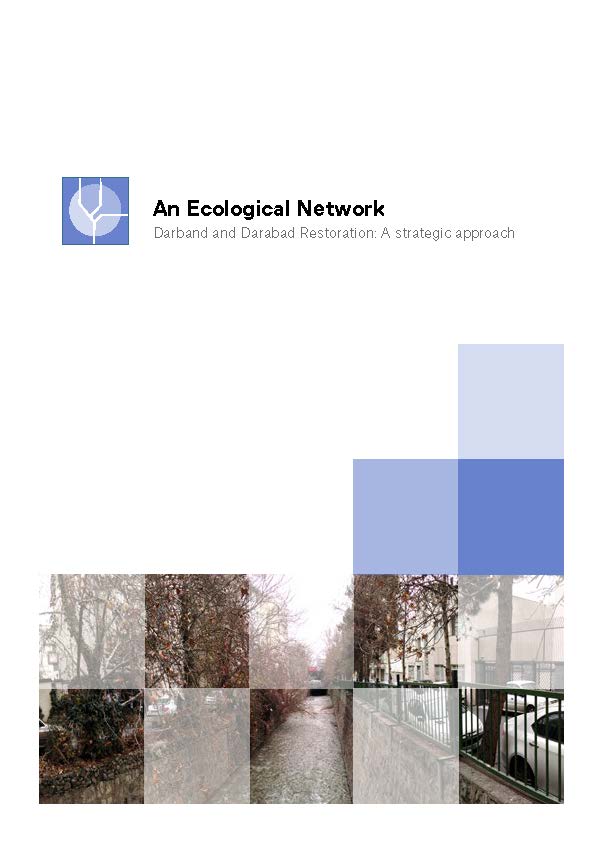
One of the most conspicuous forms of the presence of water and natural axes in the structure of Tehran, that is still detectable among the mass constructions and roadways, are the river-valleys that float from the heights of Alborz mountains to the south and after a few kilometers are guided into the watercourses. Because river-valleys throughout the years were the connecting elements between the urban fabric and nature, their importance now is not solely on their natural value, but each one of them has turned into a historical, cultural, and environmental treasure.

Although each one of the main river-valleys of Tehran, under the influence of the current urban fabric, has a distinct formal, physical-spatial, and functional characteristic, but at the same time, it also has a spatial connection with the whole network; and with an appropriate planning, it can guarantee the spatial integration of the city. That is why in the new comprehensive plan of Tehran, there has been an emphasis on a coordinated intervention and an integrated view on the main river-valleys of Tehran, and five of the seven main valley-rivers (Kan, Farahzad, Darake, Darband, DarAbad) has been considered as the main development idea.

Click Here for the Project Booklet.

Apartment 112 Residential

Apartment 112 Residential

Apartment 112, with 18 residential units and the total area of 4000 square meters has been constructed on a land of 2400 square meters in the second phase of Mehrshahr district in Karaj.

The ground floor is dedicated to the entrance lobby, multi-purpose hall, the parking lot, janitorial room, and mechanical room. Apartment units are located on the three upper floors. Each floor is comprised of six independent units and the unit areas vary from two-bedroom 110 square meters to three-bedroom 190 square meters. The building structure is a concrete framework and each unit’s installation is independent and made of split and package units. The project’s construction started in 2014 and finished in 2016.

Click Here for the Project Booklet.

Apartment 204 Residential

Apartment 204 Residential

Apartment 204, with 16 residential units and the total area of 3000 square meters, has constructed in Mehrshahr district in Karaj in 2014. This residential complex is comprised of eight 170-square-meters apartments and eight 120-square-meters apartments.

The architecture is inspired by spatial organization and circulation of iranian houses and is based on the network structure. Thus the possibility for the connection and expansion of house spaces is provided and multi-functional spaces are created.

Click Here for the Project Booklet.

Apartment 210 Residential

Apartment 210 Residential

Apartment 210, with 11 residential units and the total area of 2500 square meters has been constructed on a land of 1000 square meters in the second phase of Mehrshahr district in Karaj. Unit areas vary from two-bedroom 115 square meters to three-bedroom 210 square meters. The construction of this project began in the summer of 2012 and was completed in the spring of 2014. The structure of this building has a concrete skeleton and its mechanical installations are the mix of evaporative coolers and water heaters with split units.

Click Here for the Project Booklet.


Darband&Darabad Restoration Strategic Plan

Darband&Darabad Restoration Strategic Plan

Rivers of Tehran, especially Darband and DarAbad have a double-edged essence. From one perspective, they hardly have a place in people’s image of the city , probably because of the simple fact that historically, the city’s water supply was based on a network of qanats. Hence, long before turning into canals, these rives were  considerable barriers for development instead of a vital source of life. From another perspective, they are a significant asset in regards to current environmental risks resulting from climate change.

Click Here for the Project Booklet.

Development & Restoration of Tehran Former Military Airport (Ghal e Morghi)

Development & Restoration of Tehran Former Military Airport (Ghal e Morghi)

Immediate land lot of Velayat Park has an area of approximately 221 hectares. This lot is a section of a bigger land lot with an area of approximately 291 hectares which formerly belonged to Ghale Morghy barrack and before that to an airport with the same name and is located in the northern parts of region 19 of the 22 regions of Tehran. This lot has a roughly ellipse shape with the major diameter of 2140 meters in the northwest-southeast direction and the minor diameter of 1680 meters in the northeast-southwest direction. The development and rehabilitation plan of this lot in the agenda of this project is, in reality, the second phase of the development plan of the area which after the removal of the barrack’s fence was carried out in the initial establishment of parts of this lot for leisure and recreational spaces in connection with the surrounding texture.

Click Here for the Project Booklet.